
Glacial Lake Outburst Floods (GLOFs)
Context: A glacial lake outburst flood (GLOF) at Shintaphu Lake in northwestern Bhutan triggered sudden flash floods along the Mo Chhu and Sankosh river systems.
- This prompted immediate flash-flood warnings from India’s Central Water Commission (CWC) and district administrations across border districts in West Bengal and Assam.
About Glacial Lake Outburst Floods (GLOFs):
What It Is?
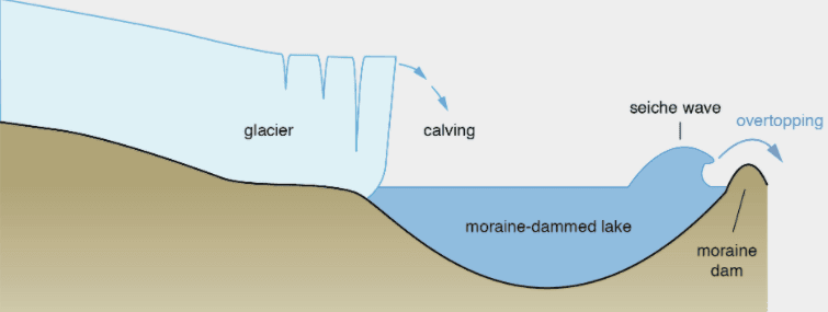
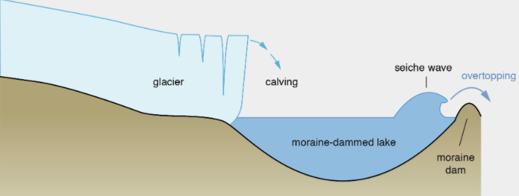
- A GLOF is a catastrophic, high-velocity release of water from a glacial lake dammed by unstable natural barriers such as moraines (loose rock and sediment), ice, or bedrock.
How It Occurs?
- As glaciers retreat and thin due to rising temperatures, meltwater collects behind unconsolidated terminal or lateral moraines.
- When this natural dam is compromised by hydrostatic pressure, internal piping, or sudden displacement waves, it breaches rapidly—releasing millions of cubic meters of water, mud, and boulders downstream within hours.
Key Data / Stats on Glacial Lakes & GLOFs:
- Glacial Lakes in the Himalayas: Over 2,000 glacial lakes have been mapped across the major river basins of the Indian Himalayan Region (Indus, Ganga, and Brahmaputra).
- Potentially Dangerous Lakes: Bhutan has officially cataloged 17 potentially dangerous glacial lakes, with Shintaphu Lake (source of the Mo Chhu River) identified as a critical hazard point.
- Rapid Lake Expansion: Remote sensing surveys indicate that proglacial lakes across the Hindu Kush Himalayas have expanded in area by over 30% to 50% over the last three decades due to accelerated glacial retreat.
- Transboundary Vulnerability: The Brahmaputra-Sankosh river basin connects upper glaciated reaches in Bhutan and Tibet with densely populated plains in downstream Indian states (Assam, West Bengal), where flood transit times range between 6 to 8 hours.
Causes of Glacial Lake Outburst Floods:
- Ice/Rock Avalanches and Calving: Massive chunks of ice or rock collapse from hanging glaciers directly into the lake, generating giant displacement waves (tsunamis) that overtop and erode the moraine dam.
- Permafrost Thawing & Structural Weakening: Rising regional temperatures melt the buried ice core inside moraine dams, causing internal subsidence, piping, and structural failure.
- Extreme Precipitation & Cloudbursts: Intense localized downpours rapidly spike lake water levels and saturate damming sediments, inducing slope liquefaction.
- Seismic Shocks (Earthquakes): Earthquakes along active tectonic faults destabilize loose moraine deposits, causing fractures and immediate breach of the dam barrier.
Implications of GLOFs:
- Destruction of Downstream Infrastructure & Energy Assets: Sudden surges of water and heavy sediment destroy roads, bridges, and energy projects along river courses.
E.g., Bhutan’s newly installed Solar Irrigation Lifting System in Punakha and the Gasa Tshachu hot springs washed away by the Shintaphu surge.
- Severe Loss of Life & Human Displacement: High-velocity flash floods strike downstream settlements with very little warning, wiping out riverine communities.
E.g., The 2013 Chorabari Lake outburst and the 2023 South Lhonak Lake GLOF in Sikkim that caused significant fatalities and devastated downstream areas.
- River Aggradation and Transboundary Flooding: Enormous silt and boulder loads deposit into riverbeds, raising bed levels and worsening chronic flood risks in downstream plains.
E.g., The swollen Sankosh and Brahmaputra rivers inundating riparian tracts in Dhubri (Assam) and Alipurduar/Jalpaiguri (West Bengal).
- Long-Term Ecological & Agricultural Disruption: Thick deposits of sterile sand and silt choke agricultural soils and damage riverine habitats, destroying aquatic biodiversity and fisheries.
E.g., Agricultural fields covered in thick sediment layers across river floodplains following flash-flood deposits.
NDMA Guidelines for GLOF Management:
- Hazard & Risk Mapping via Space Technology: Promote the use of satellite imagery (including Synthetic Aperture Radar / SAR) and drones to continuously track glacial retreat, detect new lake formations, and identify potentially dangerous lakes.
- Structural Engineering Interventions: Implement controlled draining of high-risk lakes to lower hydrostatic volume through siphoning, pumping, controlled trenching, and tunneling through moraine barriers.
- Early Warning Systems (EWS) & Automated Alarms: Install automated water-level sensors, rain gauges, and acoustic sirens linked to real-time satellite communication, accompanied by cellular emergency broadcast alerts.
- Land-Use Zoning & Infrastructure Building Codes: Enforce strict regulations prohibiting residential settlements and heavy civil construction in designated high-risk GLOF hazard zones, alongside mandatory GLOF risk audits for hydropower projects.
- Community-Based Disaster Preparedness (CBDRM): Train local communities and village volunteers as first responders, integrating traditional knowledge with institutional forces (NDRF, SDRF, Army) for swift evacuation and relief deployment.
Conclusion:
The Shintaphu Lake outburst flood highlights the growing cross-border threat that glacial lake outbursts pose to downstream regions in the Himalayas. As climate change accelerates glacial retreat across fragile mountain ecosystems, unilateral domestic measures are no longer sufficient to manage water-related hazards. Strengthening real-time transboundary data-sharing, deploying automated early warning networks, and enforcing strict mountain land-use zoning are crucial to protecting vulnerable communities in downstream river basins.
What are glacial outbursts? Discuss the concerns caused by such phenomena with suitable examples.